Christopher J. Bessert: Portfolio Samples
Displayed here are a very small sampling of some of the maps and other projects I have completed in the past few years. Additional examples, hardcopy and/or digital versions are always available upon request.
Jump to:
Portfolio | General | Recreation | Utility | University | Transportation | Websites
| General, Road and Street Maps | |
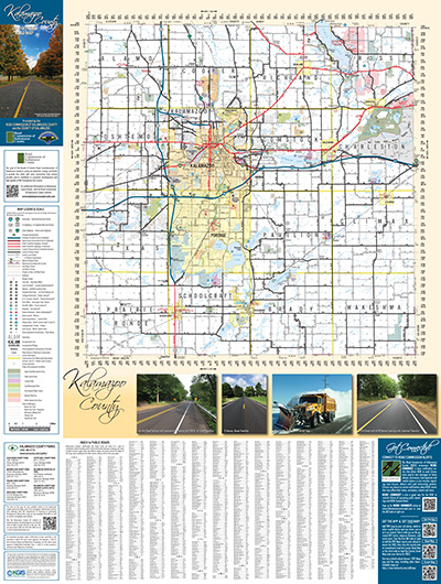
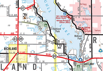
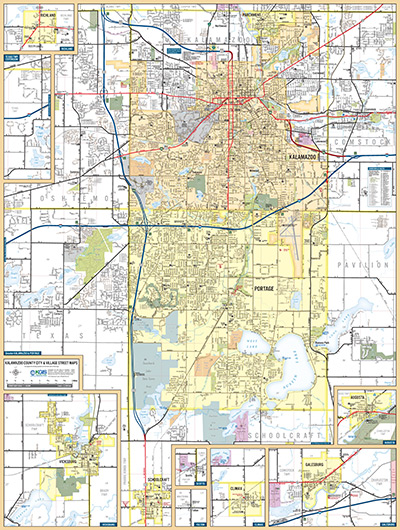
| Kalamazoo County Official Road Map 2016 | |
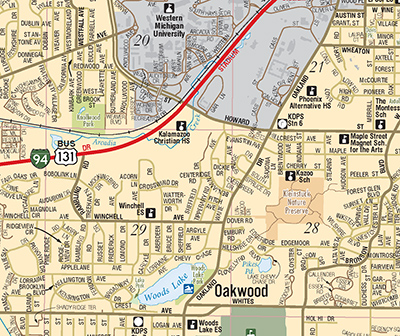 |
This is the official road map produced under the auspices of the Road Commission of Kalamazoo County and the County of Kalamazoo. For this map, I composed the overall layout within ArcGIS, then exported to Adobe Illustrator where the final cartographic touches were applied. Every aspect of the map—save for the cover photograph—was done by myself. The top map image shows a thumbnail of the entire countywide road map, mapped at a scale of 1:80,000 and measuring 25-3/2" wide by 34" tall. It also includes a complete legend, public roads index, county parks listing and links to various other Road Commission, Planning and related websites. The second image shows an enlargement of the countywide map. For the 2016 edition, the map was entirely overhauled and redesigned. The cartography was clarified and a variety of additional information was added, including all state, county and local parks, all hiking and bicycling trails, all government facilities, post offices, schools, and points of interest. The third image shows a thumbnail of the entire back side of the map, which includes street-level mapping for the entire Greater Kalamazoo/Portage area (including Parchment, Schoolcraft, Oshtemo, Texas Corners and Comstock) as well as insets for Vicksburg, Richland, Augusta, Galesburg, Climax, Scotts and Fulton. Copies of map are available free of charge from the Road Commission of Kalamazoo County offices, the Kalamazoo County Planning & Community Development Department office, and other locations around the county. Additionally, the 2016 map was also deployed to mobile technology users (iOS devices, such as iPhone and iPad, and Android devices) via the Avenza Maps app. Now the traditional paper folded map can be taken on the go, with the users' current location pinpointed on the map! The app also allows for the recording of GPS tracks, searching for features, dropping pins, and more! See the PDF Maps page on the Kalamazoo County website for details. |
| Allegan County Official Road Map 2014-2015 | |
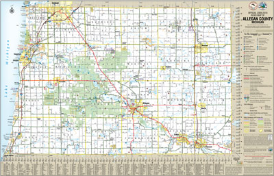 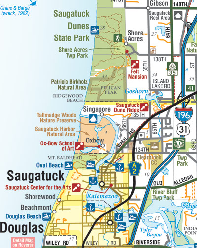 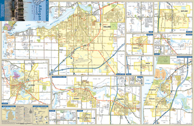 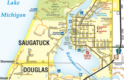 |
This is the official road map produced under the auspices of the Allegan County Road Commission and the County of Allegan. For this map, I composed the overall layout within ArcGIS, then exported to Adobe Illustrator where the final cartographic touches were applied. Every aspect of the map—save for the cover photograph—was done by myself. The top map image shows a thumbnail of the entire countywide road map, mapped at a scale of 1:85,000 and measuring 34" wide by 24" tall. It also includes a complete legend, various indicies (roads, hydrology, airports, recreational opportunities, and cultural landmarks), an explanation of the county's seasonal roads, E-911 dispatch system and countywide addressing system. The second image shows an enlargement of the countywide map. The third image shows a thumbnail of the entire back side of the map, which includes the map cover and 12 insets of fourteen of the county's cities, villages and other congested areas. The 2009-10 map marked the debut of detail maps of Hamilton, Dorr and Pullman, as well as expansions of the Saugatuck/Douglas, Plainwell/Otsego and Holland area maps. For the 2012-13 edition, insets for Burnips and Moline and additional points of interest were added. Shipwrecks and additional outdoor recreation information was added for 2014-15. Copies of map are available free of charge from Allegan County Land Information Services, the Allegan County Road Commission, many other county departments, various local government offices and local chambers of commerce. This edition of the map was also deployed to mobile technology users (iOS devices, such as iPhone and iPad, and Android devices) via the Avenza Maps app. |
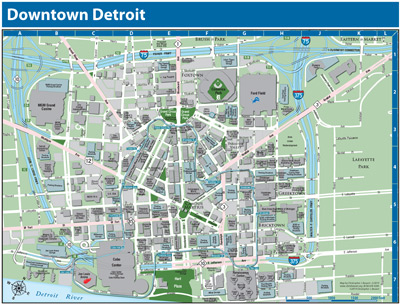
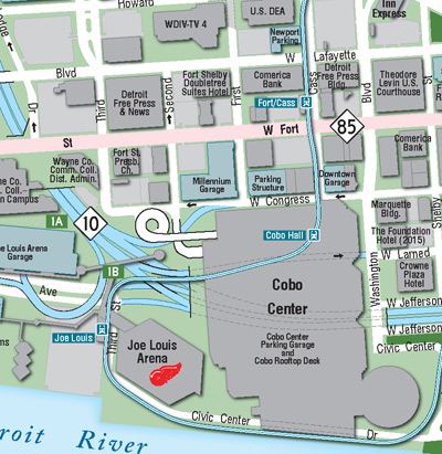
| Downtown Detroit Map | |
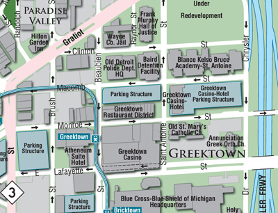 |
Begun as a project to help show the location of a new facility for one of Michigan's universities, the outgrowth was a comprehensive map of the entire downtown core of the City of Detroit. It was a project I had wanted to undertake for many years and, while very challenging, was also very rewarding in a few surprising ways. While I initially hoped to find a good source of building footprint data, my search left me empty-handed. So, I acquired some high-resolution orthophotography of the downtown area from the USGS and created my own GIS database and layer for downtown buildings! While the imagery was of sufficient resolution that I could trace each building, it was from 2011 and I quickly found that quite a bit of new development was occuring in downtown Detroit and had to supplement that base layer with additional sources. The top image at left is a thumbnail view of the entire map, while the second and third images are zoomed-in excerpts to show the level of detail. I hope to carry this map further in the future and even create a "smart" version to use used on cellphones and tablets, showing your location on the map and allowing for additional interaction. |
| Oceana County Official Road Map 2012 | |
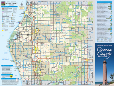 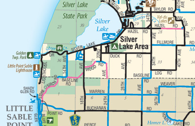 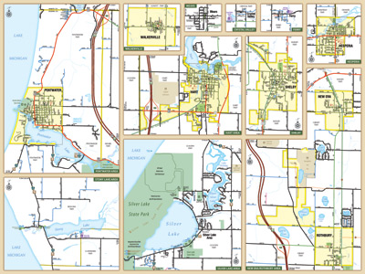 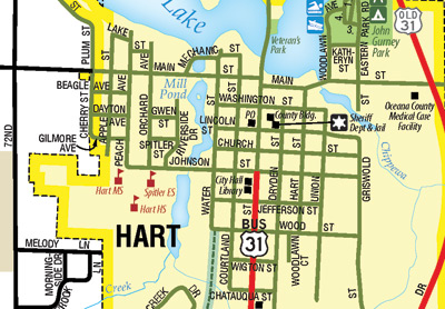 |
This is the official road map issued by the Oceana County Road Commission. The top map image shows a thumbnail of the entire countywide road map, mapped at a scale of 1:90,000 and measuring 24" wide by 18" tall. It also includes a complete legend, a complete index of all parks and natural areas in the county, an explanation of the county's seasonal roads, and information on the operation of snowmobiles along county raods. The map cover consists mainly of a photo of the Little Point Sable Lighthouse, build in 1874. The second image shows an enlargement of the countywide map. The third image shows a thumbnail of the entire back side of the map, which includes 11 insets of twelve of the county's cities, villages and other congested areas. The 2012 map marks the debut of detail maps of Ferry, Crystal Valley and Stony Lake, as well as expansions of the Pentwater, Rothbury/New Era and Hart area maps. This map, completely redrawn using the latest geographic information system (GIS) data, includes all the latest road network changes, plus the addition of all local and county parks, national forest lands, nature preserves, freeway exit numbers, snowmobile trails, and even shipwreck locations! Copies of map are available free of charge from the Oceana County Road Commission, other county departments, and some local government offices. |
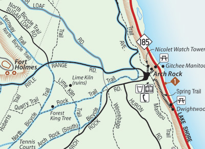
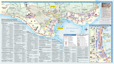
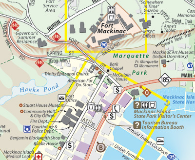
| Mackinac Island Tourism Bureau Map | |
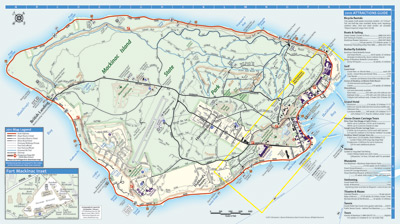
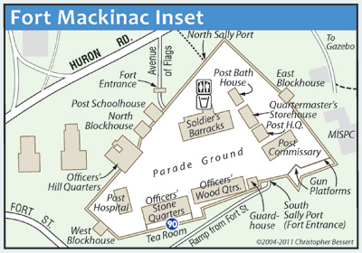 |
Having first made a fully-digital map of Mackinac Island in 1993, the current map is actually the third iteration. It was completely redrawn using more accurate GIS data in 2004 and then completely overhauled in 2011 when it was ported from Macromedia FreeHand to Adobe Illustrator. I have walked or bicycled almost every single road and trail on the Island, so this map is about as fully field-checked as any map could ever be. It has been described by others as "the most complete and accurate map of Mackinac Island... ever!" This map consists of several maps in one. First, a map of the full island showing all roads, trails, footprints of EVERY building on the Island, parks, golf courses (including greens), water features and public land ownership. This portion of the map also includes a comprehensive index of all Island visitor attractions and activities. The map includes every single road, street, trail, path, stairway and drive on the Island, classified by type and indicating surface (paved vs. gravel). Steep roads and trails are indicated where bicyclists, mountain bikers and hikers should exercise additional caution. The various bluffs which runs around the majority of the Island as well as the area around Fort Holmes are included to better show where steep climbs are encountered. A second map shows the southernmost portion of the island—the downtown area—in detail, as well as a complete index of all visitor and tourist-related businesses (lodging, dining, fudge shops, bicycle rentals, shopping, museums, etc.). An detailed inset map of the Main & Market Street Area shows the downtown core in even more detail. A third map shows Fort Mackinac, its buildings and walkways in extreme detail. |
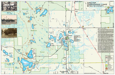
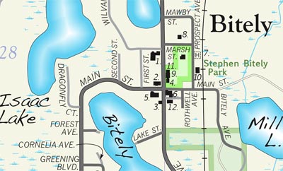
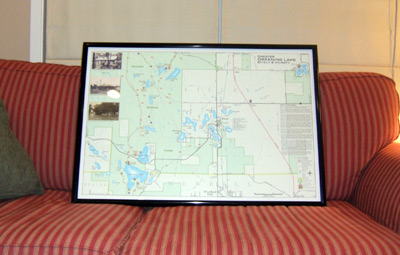
| Greater Greening Lake, Bitely & Vicinity Map | |
|
This map is a recreationally-focused map showing a portion of north-central Newaygo County, around the Bitely area. It highlights the area lakes, hiking trails, campgrounds and other recreational opportunities. It also includes several historic photos of the area along with a history of the region. Map measures 36" x 24" in size. A 400% close-up is included below the full map at left. A photograph of the finished and framed wallmap is included below left. A 34-page bound mapbook has also been created from this wallmap, including a Newaygo Co. map, lake depth maps of 11 area bodies of water, maps of several National Forest facilities and much more. |
| Osceola County Road Map 2008 | |
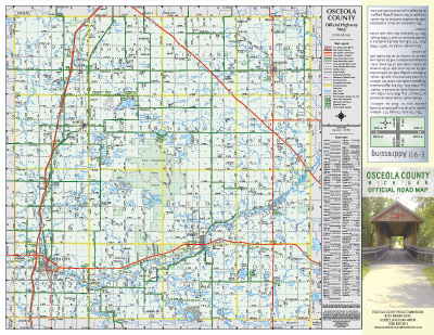 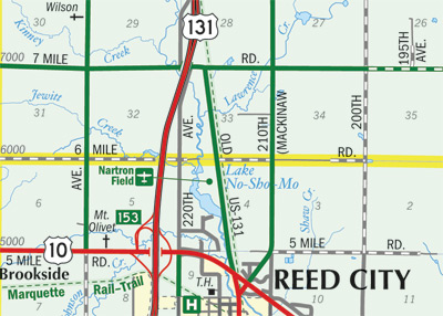 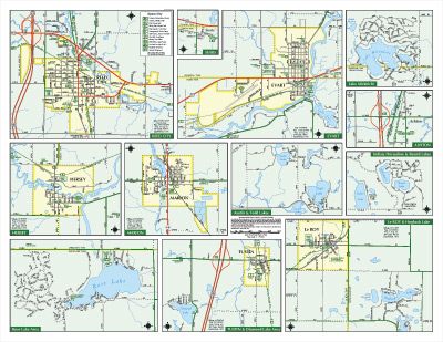 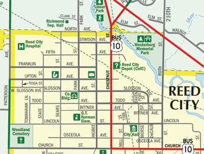 |
This map was created as a "fun" project during early 2008 and and updated version is planned to be offered to the Osceola County Road Commission soon for their use, should they find it desirable. It is a standard county-based road and recreation map as issued by most counties across Michigan. The front of the map contains a full county road map and includes all communities, parks, state lands, exit numbers, section lines and numbers, airports, cemeteries, all hydrology, and a complete road index. The reverse of the map includes twelve inset maps, one each for the two cities, four villages and other hamlets and congeste areas. These inset maps include all roads and streets, points of interests, parks, trails, cemeteries, schools, government buildings, and all hydrologic features. Map measures 17" x 22 " in size. A full-resolution version of this map in PDF format for review is available upon request. |
| City of Rockford Community Map 2008 | |
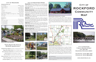 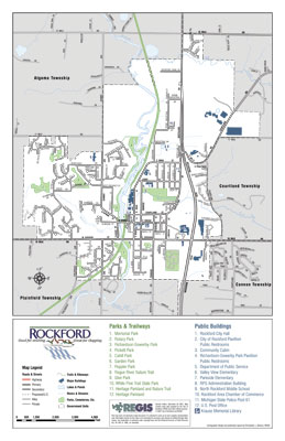 |
The City of Rockford approached me in the hopes that I could take a rather crude map-and-brochure combo created in-house and overhaul both the map and the informational portion of the publication. What had been a low-resolution and unpolished document created in Microsoft Publisher was converted into a professional-looking, high-resolution, print- and web-ready brochure. Map measures 11" x 17 " in size. Follow the link below to view or download a copy in PDF format: Rockford Community Map 2008 (1.5 MB PDF) |
| Alpine Township 160th Anniversary Map | |
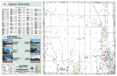 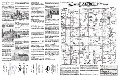 |
Previously not having available any type of street map for township residents or visitors, the Alpine Township Board and Historic Commission decided to issue a double-sided map for 2007-08, the township's 160th birthday. The full-color side features a typical street map as well as a comprehensive index and photos of major township buildings. The black-and-white side includes a reproduction of an 1876 township plat map, copious text on the history of the township and several historic photographs. Map measures 34" x 22" in size. Copies of this map are available from Alpine Township. |
| City of Grandville Street Map | |
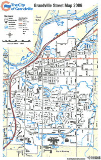 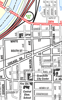 |
This project began by converting existing basemaps created by an outside engineering firm into GIS-based maps, with the first product being a street/base map. From there, additional maps, such as a Zoning Map, Voting Precinct Map, Planned Landuse Map and others were created. Map measures 11" x 17" in size. A 400% close-up is included to the right the full map at far left. |
| Downtown Grand Rapids Map | |
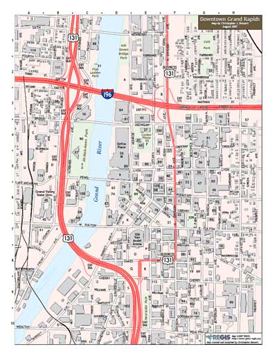 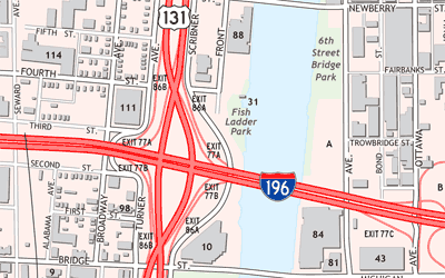 |
This map shows the downtown area of Grand Rapids in great detail, including the footprints of all buildings, many of which are indexed on the reverse side of the map. Also indexed and shown are all public parking facilities. Map measures 8.5" x 11" in size, making for easy printing for use while travelling into downtown GR. A 400% close-up is included below the full map at left. Other adaptations of this map are used by the City of Grand Rapids, Kent County and other organizations to highlight their facilities and events: • Downtown Grand Rapids Map • Parking Facilities Map • DASH Bus Map • Santa Parade Map • Celebration on the Grand Map • Kent County Courthouse Juror Parking Map |
|
|
Jump to: Résumé | Portfolio | Technology | Contact
This is a website created, authored and maintained by Christopher J. Bessert as a portal for information about him, his GIS, mapping, cartography, transportation-planning and webmastering projects, as well as a home for his resume, portfolio and a listing of many of the computer technologies and softeware he knows how to use.